Seasonal Service activation is now being scheduled after May 1.
Seasonal Service
Sebago Lake is one of Maine’s most important natural resources.
It is one of the state’s largest lakes and, at over 300 feet deep, it is the deepest lake in New England.
It serves as the drinking water supply for nearly 1/6 of Maine’s population as well as hundreds of thousands of visitors to the state each year.
Sebago Lake serves as the primary water source for nearly all PWD customers, except a small portion served by wells in Steep Falls. We take great pride in serving water sourced from Sebago Lake, Maine’s second largest and deepest lake. Surrounded by forests, the lake is exceptionally pure and of such high quality that it is exempt from the filtration requirements set by the Safe Drinking Water Act. Only about 50 out of 13,000 surface water supplies across the country are able to serve unfiltered water.
Protecting the source is the first step to ensure high-quality drinking water. PWD actively engages in numerous environmental protection efforts to help protect and preserve the quality of Sebago Lake and its watershed.
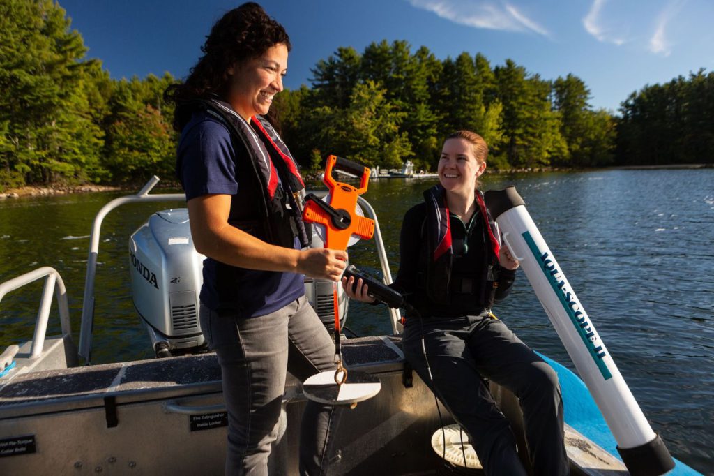
Portland Water District monitors the water quality of Sebago Lake and some of the major streams and rivers that flow into the lake.
The water quality of Sebago Lake is excellent and has been stable since PWD began its current lake monitoring program in the 1970s. PWD visits the deepest spot in each bay monthly from May to October.
PWD monitors chemical and physical characteristics of 11 of the major streams and rivers that flow into Sebago Lake. Monthly monitoring helps us keep an eye on conditions in the watershed and the quality of the water flowing into the lake. For more information, please see the Tributary Monitoring Report and the Crooked River Monitoring Report.
PWD annually monitors the aquatic insects in the Crooked, Northwest, and Muddy Rivers. This program gives us a good picture of the long-term health of the water in these rivers. For more information, please see the Biological Monitoring Report. (We do not have a report for the 2023 season because the high water levels in the rivers were unsafe for collecting samples.)
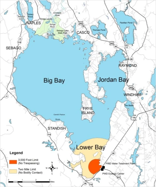
PWD monitors Sebago Lake the deepest parts of each bay of the lake – Jordan Bay, Big Bay, and Lower Bay. Physical, chemical, and biological parameters are monitored monthly from May through October.
For more information about PWD’s lake monitoring program please see the following reports:
A watershed is an area of land where precipitation collects and drains off into a river, bay, lake, or other body of water. The Sebago Lake watershed extends from Standish all the way northwest to Bethel – about 50 miles!
This means a drop of water that falls all the way up in Bethel would make its way all the way to Sebago Lake and, possibly, into a glass of your water.
| Length | 12 miles |
| Big Bay Width | 5 miles |
| Jordan Bay Width | 2 miles |
| Sebago Basin Width | 1 mile |
| Shoreline Length | 105 miles |
| Maximum Depth | 307 feet |
| Mean Depth | 101 feet |
| Volume | 995 billion gallons |
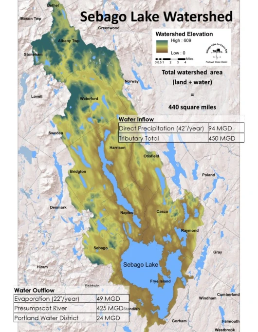
| Water Inflow | |
| Direct Precipitation (42″/yr) | 94 MGD |
| Tributary Total | 450 MGD |
| Water Outflow | |
| Evaporation (22″/yr) | 49 MGD |
| Presumpscot River | 425 MGD |
| Portland Water District | 24 MGD |
This one question will help us understand how people use our website, you will have an opportunity to add more information to your answer on the next page. Having problems with online billing? Please fill out this form: https://www.pwd.org/support-request/
Our online account management and bill payment portal is temporarily unavailable while we upgrade the system. The automated phone payment system is also temporarily unavailable. Services are expected to resume by Monday, March 3.
We apologize for any inconvenience and appreciate your patience as we work to enhance your online experience.